Q: When will the pumping and dredging start?
A: Construction is anticipated to begin around spring to early summer of 2019. This is largely contingent upon weather and other external factors.
Q: How long will the pumping go on?
A: Construction of the 3.1-mile beach project that extends from Stumphole to Rish Park will take approximately 60-days. This timeframe will depend on weather conditions, equipment issues and other external factors.
Q: Where will the pumping and dredging start?
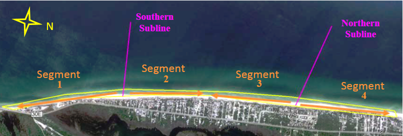
A: In general, the beach project will begin at the southern end of the project area and advance to the north toward Rish Park. There will be two “Sublines” (Southern and Northern) where pipes are connected to the dredge anchored offshore so that sand can be pumped directly onto the beach. Pumping will begin somewhere just south of the Scallop Cove Convenience Store (“Southern Subline”) and will proceed to the south along Segment 1 toward the Stumphole revetment. Once Segment 1 is complete, the contractor will then proceed to the north from the “Southern Subline” along Segment 2. Upon completion of Segments 1 and 2, the contractor will move to the “Northern Subline” to fill Segment 3 and end with Segment 4. This plan is contingent upon receiving RESTORE Act funding.
Q: Will they pump sand up in more than one place at a time?
A: It is not likely that the contractor will pump sand up in more than one place at a time.
Q: How long will the construction be in front of my property?
A: How long it will take to construct a beach segment is dependent upon a number of factors, some of which are external, so we cannot predict the actual time. However, it can be expected that the project will advance down the beach at a rate of 100 to 500 feet per day. The advancement will include the discharge of sand from the end of the pipe followed by construction equipment that will move and grade the beach. The rate of advancement will be dependent on any potential delays caused by inclement weather, equipment issues or the presence of an endangered species such as a sea turtle. Even though the active part of the project will move down the beach fairly quickly, there will be sections of pipe and equipment on the beach for most of the construction period.
Q: Will I be able to get onto the beach while the project is going on?
A: Temporary access points in the form of "sand ramps" will be constructed every 500 feet or so to allow everyone a way to get to the beach during the construction process. It might mean that you will have to walk north or south of your property to one of the temporary accesses, but you will always be able to get to the beach during construction. Pedestrian traffic may be prohibited in the 300- or 500-foot segment under “active construction”, but that would be a temporary situation for a relatively short period of time, and you can simply enjoy the beach north or south of the construction activity.
Q: Does the contractor work certain days of the week or certain hours of the day?
A: The beach restoration project is anticipated to be constructed on a 24-hour a day, 7-days a week basis. The amount of construction activity will be dependent on any potential delays caused by inclement weather, equipment issues or the presence of an endangered species such as a sea turtle.
Q: Is the construction noisy?
A: YES. The beach will be an “active construction” site that will take place 24 hours a day, 7-days a week. Bulldozers, front-end loaders and other large pieces of equipment will be used in the construction of the beach project. You will be able to tell there is an “active construction” site in your area when the operations are near or seaward of your property.
Q: Will construction equipment and laborers be accessing the beach through our property?
A: NO. The limits of construction are from the top of the dune out into the Gulf of Mexico and the contractor is prohibited from going through your property without permission from the property owner. The contractor is allowed access to the beach at the southern end of the project near the Stumphole revetment.
Q: Will I still be able to rent my home or condo during construction?
A: Yes. As with many other beach communities during construction of a beach project, rentals and owners still enjoy the beach and typical vacation activities during construction. However, it should be noted that some safety restrictions around the “active construction” site will limit access to the general public but, the beach will remain open. This will be a fast-moving project, so at this time we cannot predict where and when the crews will be working and, if it will impact your property during a given week. We will do our best to provide updates through this website as to where the crews are working and where beach access is temporarily restricted.
Q: Will I have to take my dune walkover down?
A: Not necessarily. It will depend whether or not the dune fronting your property has been eroded and will be restored during this project. Whether you remove your dune walkover before the project begins is up to you. When the dredger encounters any structure that is not removed (dune walkover, gazebos, etc.) they will only place sand up to and around it. If you leave a structure intact and the dredger places sand around it, it may not be as much sand as your property would have received if you had removed it. If you wish to remove and then reinstall your boardwalk or other structure, we suggest you check with the individual who constructed them for the best way to remove and perhaps reinstall them after construction.
Q: Will I have to get a permit to rebuild my gazebo or boardwalk that was destroyed in past storms?
A: Any activity on the beach and dune requires a permit from the Florida Department of Environmental Protection (DEP). However, the type of permit you need will depend on the size and type of structure. For walkovers that meet certain DEP criteria, a field permit may be issued. For other structures, such as gazebos, you may need to apply for and obtain a Coastal Construction Control Line (CCCL) permit from DEP.
It is extremely important that you do not begin construction of any boardwalk or other structure without obtaining the necessary permitting to do so.
The DEP CCCL Permit Manager for Gulf County is:
Ronard Ivey, Environmental Specialist II
Ronard.E.Ivey@dep.state.fl.us
850-245-7591
You can view the Sand Fence Guidelines and Dune Walkover Guidelines here. Link
Q: Will I have to plant sea oats myself?
A: As part of the restoration project, the replanting of the dunes will be undertaken at a later date. If you wish to plant your own sea oats or add additional plantings on the dune, you certainly welcome to do that.
Q: How long until the beach is the width, height and color it's going to be long-term?
A: Once the sand is placed on the beach, the shape of the constructed template will begin to adjust to a more natural shape. This adjustment is built into the design and is called "profile equilibration." This simply means that the way the beach was constructed and looks immediately post-construction is not what it will look like after the profile adjusts. The width of the dry beach will get smaller and will appear to quickly erode. This is intentional and this quantity of sand that leaves the dry beach will be deposited in the nearshore sand bar just seaward from where it was placed by the dredge. How quickly a profile equilibrates depends on the nearshore waves and currents. Once equilibration has taken place, the beach will "settle in" and the shoreline should perform as designed by our engineer. The length of time the sand remains will be dependent upon the varying intensities of storm events.
With regard to the color of the sand, when pumped on the beach the sand is wet and therefore appears darker than the existing sand. It will dry quickly and will also continue to lighten over a period of time. The sand that is proposed to be placed on the beach has been very carefully selected and put through rigorous testing by the Florida DEP and the County’s Coastal Consultant to meet criteria for color, shell content and grain size that are important to a healthy and attractive beach.
Q: If I signed the construction easement in 2008 for the first beach nourishment project, do I need to sign the new easement?
A: Yes. The original easement you signed from the first project expires on November 1, 2017. Please sign, notarize, and return the new easement, which will be effective for a 10 year period until November 1, 2027.
Q: Why is the easement duration for a period of 10 years?
A: The 10-years allows for the initial construction of the project, conduct post-construction field monitoring, post-storm assessments and mitigation, and may allow a second re-nourishment within the 10-year period. The Easement for the first project constructed in 2008-2009 was also for a 10-year period.
Q: If I don't sign a construction easement, does that mean the Erosion Control Line will not go into effect for my property?
A: No. The implementation of the Erosion Control Line, or ECL, is completely independent of your construction easement. Public hearings on the ECL were held on May 22, 2007. The ECL was drawn where the existing Mean High Water Line was surveyed in November of 2006. There will be no updates to the location of the ECL.
Q: If I sign a construction easement, does it mean I am giving away some of my property to the County or the State?
A: No, you are not giving away property or property rights. You are simply signing a construction easement that will allow the temporary placement of the pipeline on your private property, will allow workers to step onto your private property during the construction process, and will allow the placement of a large amount of sand on your private property to reconstruct the dune line and berms.
Q: If I don't sign a construction easement, does that mean I don't have to pay the MSTU tax anymore?
A: The MSTU is a tax that will continue to be levied on your property's value whether you sign the construction easement or not.
Q: If I don't sign a construction easement, will that stop the beach project?
A: We do not require 100% return of the construction easements for the beach project to be constructed.
Q: If I don?t sign a construction easement, will they still put sand in front of my property?
A: Without permission to come onto your private property, the contractor will not be able to place sand landward of the Erosion Control Line, on your private property. The construction will, instead, "build around" your property seaward from the ECL. The beach will be the same width as your neighbors on either side, but you will not have the dune and berm in front of your property as they will if they have signed a construction easement.
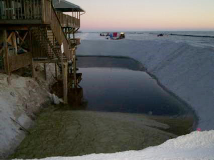
Q: If my property is "built around" by the project, what will it look like?
A: It is impossible to say precisely what the appearance of your property will be if you elect not to sign a construction easement and sand is only placed from the ECL seaward. A photo of what one such property looked like after construction can be viewed below. Typically, however, you will have no berm or dune structure in front of your property. You will have an area that is much lower than the surrounding beach as a result. Sometimes these areas will fill with water for some period of time.
Q: If my neighbor doesn't sign a construction easement, is there anything I can do about it?
A: It is your neighbor's legal right to choose not to sign a construction easement. Please be sure, however, they have seen the FAQs with regard to the construction easement and what it does and does not mean to them as a private property owner.
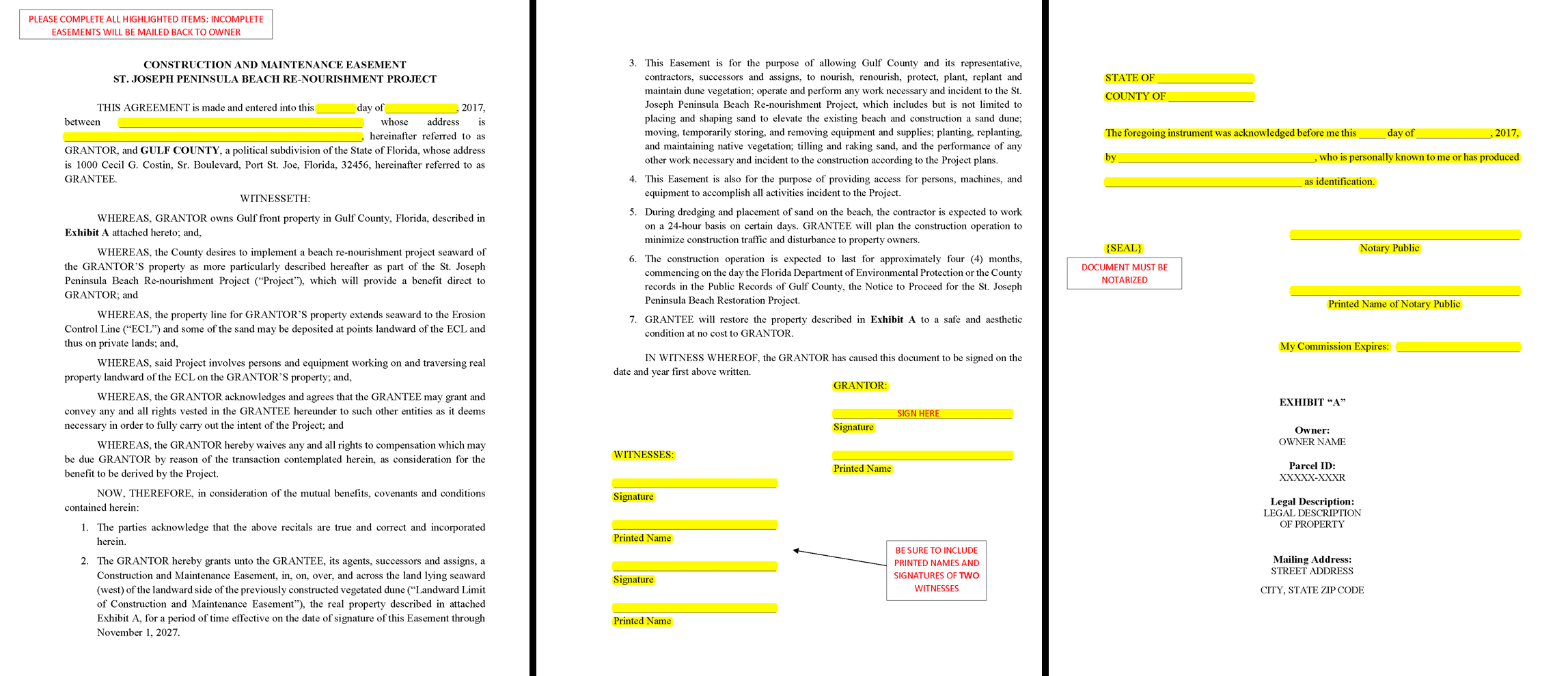
Q: How do I fill out the easement paperwork?
A: Please fill out all highlighted items as shown in the example below. The owner, two witnesses and a notary need to sign the document. We will have to re-mail the easement to you if it is not correctly filled out.
Q: Who can sign the Easement and do all the owners need to sign?
A: Only the legal owner of the property or Power of Attorney can sign the easement. If the property is jointly-owned, only one of the listed owners needs to execute the easement.
Q: What address do we use in the first paragraph of the Easement?
A: Your home or mailing address is sufficient.